



AeroStrata UAS Drone Services
DJI Mavic 3 Enterprise
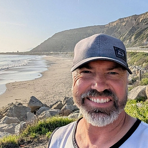
Provided by Ethan
About the Service
AeroStrata UAS Analytics provides professional commercial drone photography, aerial mapping, and site documentation services throughout Southern California and surrounding regions.
As an FAA Part 107-certified Remote Pilot, I specialize in capturing high-quality aerial imagery and accurate visual data for real estate, construction, land development, infrastructure, and commercial property projects.
**Services include:**
- Residential, commercial, and vacant land aerial photography
- RTK-enabled drone mapping and orthomosaic data collection
- Construction progress monitoring and site documentation
- Solar farm and battery energy storage facility visual documentation
- Roof, building exterior, and infrastructure photography
- Property boundary and terrain visualization
- RAW (DNG) and JPEG photography
- Ground-level photography and video documentation
My professional background in technical operations, logistics, and site safety brings an additional level of planning and coordination to every assignment.
I understand the importance of following detailed client shot lists, maintaining safe operations, documenting site conditions, and delivering organized files that meet project requirements.
Whether you need a single property photographed or recurring aerial documentation of a construction project, AeroStrata UAS Analytics is committed to professional service, reliable communication, and quality results.
Drone Models Supported:
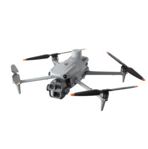 DJI Matrice 4 Enterprise
About the Drone
**AeroStrata UAS Analytics — Professional Drone Equipment**
AeroStrata UAS Analytics utilizes professional DJI Enterprise drone technology for aerial photography, precision mapping, construction documentation, property inspections, and specialized data collection.
**DJI Mavic 3 Enterprise (M3E) — Primary Aircraft**
Our primary aircraft is the DJI Mavic 3 Enterprise, designed for high-resolution photography, precision mapping, and commercial site documentation.
Key capabilities include:
- 20MP 4/3 CMOS camera
- Mechanical shutter for reduced motion distortion
- RTK positioning for improved mapping accuracy
- Simultaneous RAW (DNG) and JPEG photography
- Automated mapping missions and repeatable flight paths
- Orthomosaic and photogrammetry data collection
- Construction progress and property documentation
**DJI Matrice 4T — Specialized Thermal & Inspection Capability**
For projects requiring thermal imaging and advanced visual inspection, the DJI Matrice 4T may be arranged based on project requirements and equipment availability.
Its capabilities include:
- Radiometric thermal imaging for temperature-related assessments
- High-resolution visible-light photography
- Multiple camera perspectives and zoom capabilities
- Laser rangefinder for distance measurements
- RTK positioning support
- Solar facility, rooftop, building, and infrastructure inspection applications
- Low-light observation capabilities
Thermal inspections are subject to equipment availability, environmental conditions, and the scope of the requested service.
**Ground-Level Photography & Video**
For assignments requiring additional ground documentation, I also utilize a DJI Osmo Pocket 3 for stabilized photography and video capture.
Equipment and mission planning are selected according to each project's requirements, location, airspace restrictions, and safety considerations.
**Our goal is to deliver accurate, organized, high-quality visual data that clients can confidently use for their projects.**
Drone Features
Customizations
RTK Precision Mapping:
RTK-enabled positioning for accurate aerial mapping and geospatial data collection.
Mechanical Shutter Photography:
20MP mechanical-shutter imaging reduces motion distortion during mapping flights.
RAW + JPEG Simultaneous Capture:
Capture original DNG RAW and JPEG photographs during the same mission.
Orthomosaic & Photogrammetry:
Aerial image collection for orthomosaics, 3D models, and point clouds.
Construction Progress Monitoring:
Repeatable aerial missions for documenting construction progress over time.
Solar & BESS Site Documentation:
Visual documentation of solar farms, battery storage facilities, and infrastructure.
Commercial Property Inspections:
High-resolution photography of rooftops, building exteriors, and site conditions.
Ground Photography & Video:
DJI Osmo Pocket 3 available for supplemental ground-level imagery and stabilized video.
Remote Site Operations:
Experience with remote locations, challenging terrain, and complex site logistics.
Thermal Imaging by Arrangement:
DJI Matrice 4T thermal inspection capability may be arranged for qualifying projects, subject to availability.
Pricing
Price
$175.00
Cancellation
Regular
Weekly Discount
10%
Monthly Discount
15%
Location