



Drone Survey, Inspection, and Photography/Videography Services
DJI Phantom 4 Pro v2.0
Provided by Michael
About the Service
I have 689 hours, 12 minutes, and 32 seconds of flight experience as of September 2025. My experience covers a number of industries. I've organized my flight hours into different objectives which you can see below:
Academy Training – 34.0
Client Training – 9.4
Inspection – 274.9
Personal Training – 46.8
Photography – 87.0
Survey – 403.7
Thermal Inspection – 24.8
Videography – 33.2
Going by the hours, surveying is my specialty. I can offer digital GIS products from my surveys, or just the photos if you do not require processing. I must add that while such products can have high relative accuracy, which will make for accurate measurements, they will only have as much absolute (global) accuracy as the GPS on the drone will allow, which is not "survey-grade" accuracy.
I use a DJI Phantom 4 Pro V2.0 for surveying. If higher absolute accuracy is necessary, I may be able to work with a land surveyor if you can supply one. They will be able to tag specific coordinates during a drone survey in order to process my products with high absolute accuracy. Alternatively, if you use a software solution that will line my maps up with other maps or overlays to a sufficient degree, that can also be a viable option for you.
I can also offer photography and videography services. I can capture sweeping views of your subject with a series of photos and videos, and I can also provide custom shots whenever feasible. I will not be able to offer more than raw photos and videos at this time, but with the photos, the work truly speaks for itself more often than not.
Lastly, I can also offer inspection services and capture specific photos for inspection, but I must note that I cannot provide actual inspection results. I can only provide the photos, and they will still need to be reviewed by an expert. Inspection services also extend to thermal inspections, but any analysis and/or determination of results is not something I am able to cover at this time. I can only provide the photos.
That covers my experience and capabilities, and personally, I am up for anything as long as it is legal, safe, and feasible. Please feel free to reach out if you have any additional questions about my services. Thanks for reading!
Drone Models Supported:
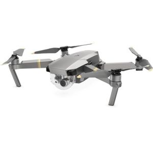 DJI Mavic Pro Platinum
About the Drone
I use a DJI Phantom 4 Pro V2.0 for surveying and photography/videography. I typically use a DJI Mavic Pro Platinum only for photography/videography, and I have a DJI Matrice 4T, which I can use for thermal inspections and thermal surveys.
Experience

Construction
Insurance Claims
Real Estate
Cinematography
Pricing
Price
$120.00
Cancellation
Regular
Weekly Discount
20%
Monthly Discount
25%
About the Provider
I am a Remote Pilot who is currently mainly contracted with Exactus Energy, Inc. as a Remote (Drone/UAV/sUAS) Pilot/Contractor and with Zeitview (formerly DroneBase) as a Remote (Drone/UAV/sUAS) Pilot for Commercial Aerial Surveying, Professional Real Estate Photography, Professional Videography, and Inspections*.
*Conducting all tasks as a Remote Pilot and contractor for purposes of gathering information and not as a licensed inspector. Not responsible for determination of project feasibility or inspection results.
Verification
Email Address
Phone Number
FAA Drone Registration
FAA Remote Pilot Certification
Location