

SkyFrame Imaging LLC
DJI Inspire 1 Pro
Provided by SkyFrame Imaging LLC
Videos
About the Service
Our goal is to offer high quality aerial photography and videography, services to our clients. SkyFrame Imaging has taken part in multiple real estate projects including residential properties and rural vacant land shoots. We also offer construction site progress documentation, inspection, and survey mapping services. Our UAV platforms are capable of accomplishing a wide variety of tasks and we are always open to unique projects. If there's a service you don't see listed here please don't hesitate to contact us!
Drone Models Supported:
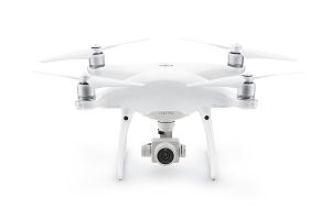 DJI Phantom 4 Professional
About the Drone
The Inspire 1 Pro is a fantastic UAV platform for just about every project. It's ability to mount various cameras and sensors makes it as versatile as it is powerful. It's incredibly stable, extremely fast, and capable of operating in 20 mph winds while still getting the shot you need. A great tool for all projects it exceeds at capturing cinema grade video. Attach a thermal camera and you have the perfect craft for industrial inspection or search and rescue. Switch out the camera for a NDVI sensor and you have a machine for gathering precision agricultural data.
The Phantom 4 Pro may be the little brother to the Inspire but it's more than capable of completing many of the same tasks. It's 20 mp camera with it's powerful 1 inch sensor is quite impressive. For photography it rivals and may even surpass the Inspire in image quality. It can also shoot 4K video at 60fps making it a great piece of equipment for cinematography, real estate video and photography, and even inspections. All this is packed into a compact and sleek design.
Experience
Construction
Real Estate
Cinematography
Drone Features
Camera
Still Camera Resolution:
16.0 megapixels
Built-in Camera:
Yes
Camera Control Range:
-90 to +30 °
View All
Controller
Mobile Device Holder:
Smartphone
Control Type:
5000.0 meters
Control Type:
Remote Control + Phone/Tablet
Live View:
Yes
View All
Customizations
DJI Zenmuse Z3 Camera:
3.5x optical zoom
Drone
Weight:
2870.0 grams
Maximum Flying Time:
15.0 minutes
Maximum Flying Speed:
18.0 m/s
Maximum Flying Altitude:
120 meters
View All
Extras
SD Card Types:
Micro SD
Pricing
Price
$150.00
Cancellation
Flexible
Weekly Discount
20%
Monthly Discount
30%
About the Provider
SkyFrame Imaging LLC was founded in 2017 in Joseph Oregon. Our goal is to offer high quality aerial photography and videography, services to our clients. SkyFrame utilizes professional grade photography drones to capture images for real estate, crop scouting and construction site project documentation, cell tower inspections, and any other aerial imaging services we are able to provide.
Our sUAS’s (small unmanned aerial systems) are piloted by FAA commercially licensed and insured drone operators. We are familiar with and follow all FAA regulations regarding drone operations and are always learning and staying up to date as this industry evolves. Our pilots are also recognized as certified Drone Tower Inspectors by Technical Rescue Systems.
Founder, business owner, and remote pilot Garrett Leo, has lived and worked with his family in Wallowa County for the past 5 years and has been a resident in the Pacific Northwest for more than 20 years. Having worked in the hospitality industry for many years we strive to bring the same level of dedication to customer needs to our UAV service as well.
Verification
Email Address
Phone Number
FAA Drone Registration
FAA Remote Pilot Certification
Location