
Picture Pilot Professional Drone Services
DJI MAVIC 3
Provided by Picture Pilot
About the Service
I am the Picture Pilot Bryce, and can provide any drone services you may need. I have extensive training and experience not only in civilian mapping and arcGIS services, but I am highly trained by the military in geospatial data, GIS, mapping, and imagery. I provide quick service getting locations mapped or inspected, and spend the required amount of time to provide survey grade accurate maps and data to my clients.
Drone Models Supported:
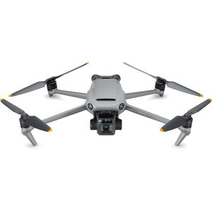 DJI MAVIC 3
About the Drone
To complete all my drone mapping projects and difficult inspections I utilize a DJI Mavic 3 Enterprise. This drone is a beast and was made specifically for mapping and inspections. My drone is outfitted with an RTK model which allows me to provide accuracy within a tenth of a centimeter (.10 cm). This drone is also very fast and can map 40 acres in approximately 15 minutes.
For all of my other projects where videos and photos will be the focus I utilize a DJI Mavic 3 Classic, which is a powerhouse when it comes to imagery with its 20 megapixel camera. I have extensive training and experience in photo and video editing.
Experience
Construction
Agriculture
Insurance Claims
Offshore Oil & Gas
Police
Fire
Journalism
Real Estate
Utilities
Pipelines
Mining
Clean Energy
Cinematography
Drone Features
Camera
Built-in Camera:
1
Customizations
RTK Module:
1
Pricing
Price
$100.00
Cancellation
Regular
Weekly Discount
20%
Monthly Discount
30%
Location