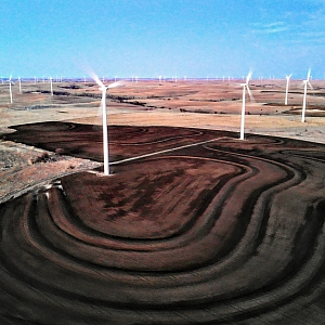
Precision Mapping and Photograp

DJI Mavic 2 Enterprise Dual
Provided by Richard
Fayetteville, AR
About the Service

Photography- Residential and Commercial Real Estate

Mapping- Construction, Subdivision, Infrastructure, Agriculture I

Drone Models Supported:
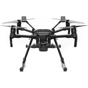
DJI Matrice 210 Series V2 RTK
About the Drone

I use several cameras on a Mavic2 Enterprise Dual and Matrice 210.

HIGH RESOLUTION
INFRARED
MULTI-SPECTRAL
LIDAR

Drone Features
  Application
App Compatibility: DJI PILOT
  Battery
Drone Battery Capacity: 3850 mAh
Battery Weight: 297 grams
Charge Time: 90 minutes
Drone Battery Type: LiPo
View All
  Camera
Built-in Camera: 1
  Controller
Live View: 1
  Drone
Wingspan or Diagonal Length: 354 mm
Weight: 1100 grams
Maximum Flying Time: 31 minutes
Maximum Ascent Speed: 4 m/s
Maximum Descent Speed: 3 m/s
View All
  Extras
SD Card Types: Micro SD
Pricing
Price
$75.00
Cancellation
Strict
Weekly Discount
0%
Monthly Discount
0%
About the Provider

Seven years experience in Geospatial and Commercial Photography and Videography. 

Verification
Email Address
Phone Number
FAA Drone Registration
FAA Remote Pilot Certification
Location
Book Now
$75.00 Per Day
Booking Start 06:00 am
Booking End 10:00 pm
$75.00 x 0 days x 1 Qty
$0.00
US Service Fee
$0.00
Booking Fee
$7.00
Total
$0.00
Cancellation Policy
Strict
Up Sonder is optimized to work in portrait mode on mobile.
Please rotate your screen.
Thank you for your interest in renting at Up Sonder!
Sign up for updates here: Sign Up
We will get in touch soon once the listings are available for renting out!