
Stevens Aerial Imaging
DJI Phantom 4 Pro v2.0
Provided by Jimmy
About the Service
Stevens Aerial Imaging has worked with projects such as:
- the "MacDill 48 Stormwater Redirect Project" with the city of Tampa and Kimmins Contracting Corp., showing that
we can qualify for "Certificates of Authorization" from the FAA in a "zero flight level" area near MacDill AFB.
- 2D orthomosaic maps, showing construction progression over 8 months, for a local construction company
- a "hyperlapse" from a height of 400 feet for a commercial real estate firm, showing traffic patterns in the area interchange.
- a "site survey" for a roofing and solar panel distributor, so they could accurately quote them a price for a solar array.
- 12 photos for an empty lot in Citrus County, Florida for a local realtor to show at her Chamber of Commerce meeting.
-
Drone Models Supported:
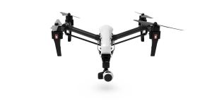 DJI Inspire 1
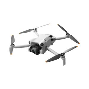 DJI Mini 4 Pro
About the Drone
The DJI Phantom 4 Pro V2.0, with its 1" CMOS sensor, is capable of taking pictures at 20 MP and video at up to 4K/60fps.
It is the best drone for construction progression monitoring, 2D and 3D maps and models, high quality photos and imagery, and stockpile monitoring.
If you need thermographic imagery, specifically for rooftop inspections or solar panel inspections, I have the DJI Inspire 1 with the DJI Zenmuse XT "advanced radiometric" lens, which gives you a resolution of 640 by 512 pixels.
Experience
Construction
Insurance Claims
Real Estate
Utilities
Clean Energy
Cinematography
Drone Features
Customizations
DJI Z3 Lens on Inspire 1:
For up to 7X zoom
DJI Zenmuse XT lens:
For rooftop inspections and solar panel inspections
Pricing
Price
$120.00
Cancellation
Flexible
Weekly Discount
20%
Monthly Discount
30%
Location