Aerial Mapping Services
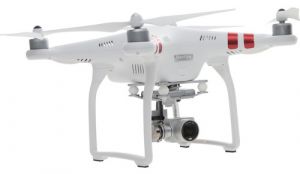
DJI Phantom 4 Professional
Provided by Nicholas
About the Service
Aerial mapping services (farm, plant health, orthophoto, 3D) using DJI Phantom drones. Experience includes real estate, farm mapping, inspections, event video, etc. Mapping is for information purposes as surveying items require a licensed surveyor. I also do post editing using Photoshop, Lightroom, iMovie, and other software for an additional charge. DroneDeploy is used for mapping projects. Availability is evenings during the week and weekends after 10:00 AM.
Drone Models Supported:
 DJI Phantom 3 Standard
About the Drone
With a 20 MP, 1" sensor camera on my DJI Phantom 4 Pro, I have the ability to shoot photos in raw or jpg format and can control both shutter and aperture during flight. Video can be shot at up to 4K 60fps. Capturing these allows for very detailed photos
Experience
Construction
Agriculture
Real Estate
Cinematography
Drone Features
Controller
Control Type:
7000 meters
Control Type:
Remote Control + Phone/Tablet
Mobile Device Holder:
Smartphone
Live View:
Yes
View All
Drone
Weight:
1388 grams
Maximum Flying Time:
30 minutes
Maximum Flying Speed:
20 m/s
Maximum Flying Altitude:
6000 meters
View All
Extras
SD Card Types:
Micro SD
Pricing
Price
$300.00
Cancellation
Regular
Weekly Discount
20%
Monthly Discount
30%
About the Provider
I am a Civil Engineer and do aerial work in the evenings and weekends using my DJI Phantom drones. Services include aerial mapping (plant health, mosaic orthophoto, 3D renderings), aerial photographs and video for items like real estate, inspections, farming, etc. Items such as events and certain airspace require extra coordination due to FAA requirements.
Verification
Email Address
Phone Number
FAA Drone Registration
FAA Remote Pilot Certification
Location


