Geaux Media, Covington, LA
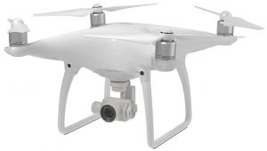
DJI Phantom 4 Professional
Provided by Geaux Media
About the Service
Former Multi-engine/Instrument rated pilot. Proficient in a number of sUAV flight utilities to ensure smooth, efficient capture of data and images. Returning the results you're looking for. View/share with strategic partners online. We guarantee our work. FAA Part 107 Certified Remote Pilot Certificate.
Offering: Aerial photos, Aerial Video, 3D Mapping, Aerial Surveying, Orthomosaic 2D mapping (viewable using Google Earth), Stockpile Volumetrics, color graded contour maps.
Drone Models Supported:
 DJI Phantom 4
About the Drone
DJI Phantom 4 Pro. 4K Camera.
Experience
Construction
Agriculture
Real Estate
Cinematography
Drone Features
Controller
Control Type:
7000 meters
Control Type:
Remote Control + Phone/Tablet
Mobile Device Holder:
Smartphone
Live View:
Yes
View All
Drone
Weight:
1388 grams
Maximum Flying Time:
30 minutes
Maximum Flying Speed:
20 m/s
Maximum Flying Altitude:
6000 meters
View All
Extras
SD Card Types:
Micro SD
Pricing
Price
$400.00
Cancellation
Regular
Weekly Discount
15%
Monthly Discount
30%
About the Provider
Small Business Marketing Firm, with a focus on Aerial Photography, Aerial video and Aerial Surveying
Verification
Email Address
Phone Number
FAA Drone Registration
FAA Remote Pilot Certification
Location


