

Osprey Geospatial Solutions
sensefly eBee Plus
Provided by Osprey Geospatial
Videos
About the Service
Osprey Geospatial Solutions specializes in integrating emerging unmanned aerial system (UAS) technologies with global positioning system (GPS) and geographical information system (GIS) technologies in order to provide top of the line solutions that help our clients succeed. Using both both quad-copter and fixed wing UAS platforms with a variety of payloads (i.e. sensors), Osprey Geospatial strives to maximize our clients’ efficiency while preserving their resources and maintaining optimal data security. These highly efficient UAS platforms, along with our GPS systems, and GIS capabilities and advanced industry knowledge, allow Osprey Geospatial the ability to deliver a variety of solutions to meet your geospatial, geomatic, and mapping needs.
http://www.ospreygeospatial.com/
Drone Models Supported:
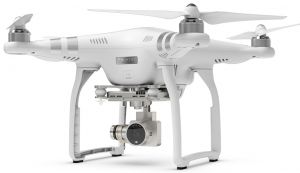 DJI Phantom 3 Advanced
About the Drone
Our fixed wing UAV gives us large coverage capabilities. This photogrammetric system can efficiently image large areas in a short amount of time. The eBee Plus is RTK capable giving it the ability to capture images that allow for survey grade geometric accuracy. These high resolution images serve as an input into our Structure from Motion software and result in orthomosaic images, digital surface models, and highly densified 3D point clouds.
Our quadcopter UAV is the perfect platform for capturing aerial imagery for real estate, small area mapping, and 3D modeling of structures.
Experience
Construction
Agriculture
Real Estate
Clean Energy
Pricing
Price
$2000.00
Cancellation
Flexible
Weekly Discount
0%
Monthly Discount
0%
About the Provider
Osprey Geospatial Solutions specializes in integrating emerging unmanned aerial system (UAS) technologies with global positioning system (GPS) and geographical information system (GIS) technologies in order to provide top of the line solutions that help our clients succeed. Using both both quad-copter and fixed wing UAS platforms with a variety of payloads (i.e. sensors), Osprey Geospatial strives to maximize our clients’ efficiency while preserving their resources and maintaining optimal data security. These highly efficient UAS platforms, along with our GPS systems, and GIS capabilities and advanced industry knowledge, allow Osprey Geospatial the ability to deliver a variety of solutions to meet your geospatial, geomatic, and mapping needs.
Verification
Email Address
Phone Number
FAA Drone Registration
FAA Remote Pilot Certification
Location